Jordi Bolibar1,2, Antoine Rabatel1, Isabelle Gouttevin3, and Clovis Galiez4
1Univ. Grenoble Alpes, CNRS, IRD, G-INP, Institut des Géosciences de l’Environnement (IGE, UMR 5001), Grenoble, France
2INRAE, UR RiverLy, Lyon-Villeurbanne, France
3Univ. Grenoble Alpes, Université de Toulouse, Météo-France, CNRS, CNRM, Centre d’Études de la Neige, Grenoble, France
4Univ. Grenoble Alpes, CNRS, Grenoble INP, LJK, Grenoble, France
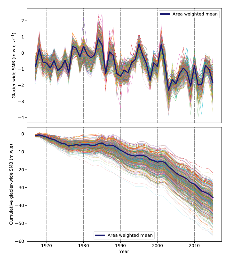
Abstract. Glacier surface mass balance (SMB) data are crucial to understand and quantify the regional effects of climate on glaciers and the high-mountain water cycle, yet observations cover only a small fraction of glaciers in the world. We present a dataset of annual glacier-wide surface mass balance of all the glaciers in the French Alps for the 1967–2015 period. This dataset has been reconstructed using deep learning (i.e. a deep artificial neural network), based on direct and remote sensing SMB observations, meteorological reanalyses and topographical data from glacier inventories. This data science reconstruction approach is embedded as a SMB component of the open-source ALpine Parameterized Glacier Model (ALPGM). An extensive cross-validation allowed to assess the method’s validity, with an estimated average error (RMSE) of 0.49 m w.e. a−1, an explained variance (r2) of 79 % and an average bias of +0.017 m w.e. a−1. We estimate an average regional area-weighted glacier-wide SMB of −0.72 ± 0.20 m w.e. a−1 for the 1967–2015 period, with moderately negative mass balances in the 1970s (−0.52 m w.e. a−1) and 1980s (−0.12 m w.e. a−1), and an increasing negative trend from the 1990s onwards, up to −1.39 m w.e. a−1 in the 2010s. Following a topographical and regional analysis, we estimate that the massifs with the highest mass losses for this period are the Chablais (−0.90 m w.e. a−1) and Ubaye and Champsaur ranges (−0.91 m w.e. a−1 both), and the ones presenting the lowest mass losses are the Mont-Blanc (−0.74 m w.e. a−1), Oisans and Haute-Tarentaise ranges (−0.78 m w.e. a−1 both). This dataset (available at: https://doi.org/10.5281/zenodo.3663630) (Bolibar et al., 2020a) – provides relevant and timely data for studies in the fields of glaciology, hydrology and ecology in the French Alps, in need of regional or glacier-specific meltwater contributions in glacierized catchments.
Full access to the preprint under revision: https://www.earth-syst-sci-data-discuss.net/essd-2020-35/
Full access to the open dataset: https://zenodo.org/record/3663630


Leave a comment